
Delwedd:Oceanias Regions.png
Wedi ei chwyddo hyd yr eithaf.
Oceanias_Regions.png (552 × 350 picsel, maint y ffeil: 20 KB, ffurf MIME: image/png)

|
This locator map image could be re-created using vector graphics as an SVG file. This has several advantages; see Commons:Media for cleanup for more information. If an SVG form of this image is available, please upload it and afterwards replace this template with
{{vector version available|new image name}}.
It is recommended to name the SVG file “Oceanias Regions.svg”—then the template Vector version available (or Vva) does not need the new image name parameter. |
| Disgrifiad |
Català: Regions d'Oceania.
Čeština: Regiony Oceánie.
Deutsch: Regionen Ozeaniens.
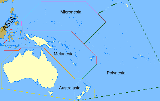
English: Regions of Oceania. Regions of Oceania: In its narrow usage Oceania refers to Polynesia (including New Zealand), Melanesia (including New Guinea) and Micronesia. In wider usage it includes Australia. It may also include the Malay archipelago. In uncommon usage it includes islands such as Japan and the Aleutian Islands.
Limburgs: Regio's van Oceanië.
Русский: Регионы Океании.
Саха тыла: Океания регионнара.
Svenska: Oceaniens regioner.
తెలుగు: ఓషియానియా ప్రాంతాలు.
Tiếng Việt: Các khu vực của châu Đại Dương. |
| Dyddiad | 17 Chwefror 2008 (original upload date) |
| Ffynhonnell | Transferred from en.wikipedia to Commons by Grillo using CommonsHelper. |
| Awdur | ASDFGH at Saesneg Wicipedia |
Trwyddedu
| Cafodd y gwaith hwn ei ryddhau i'r parth cyhoeddus gan ei awdur, ASDFGH at Saesneg Wicipedia. Mae hyn yn weithredol ledled y byd. Hwyrach nad yw hyn yn bosib yn ôl cyfraith rhai gwledydd; os felly: Mae ASDFGH yn rhoi i unrhywun yr hawl i ddefnyddio'r gwaith hwn at unrhyw ddiben, heb unrhyw amodau, oddieithr unrhyw amodau gofynnol yn ôl y gyfraith. |
Cofnod lòg yr uwchlwythiad gwreiddiol
The original description page was here. All following user names refer to en.wikipedia.
- 2008-02-17 00:28 ASDFGH 552×350× (17433 bytes)
Hanes y ffeil
Cliciwch ar ddyddiad / amser i weld y ffeil fel ag yr oedd bryd hynny.
| Dyddiad / Amser | Bawdlun | Hyd a lled | Defnyddiwr | Sylw | |
|---|---|---|---|---|---|
| cyfredol | 13:20, 18 Medi 2011 | | 552 × 350 (20 KB) | Maphobbyist | Map depicting continents according to plate tectonics. The Eastern Sunda Islands and the Moluccas are also part of the Asian tectonic plate. |
| 16:57, 30 Hydref 2008 |  | 552 × 350 (17 KB) | File Upload Bot (Magnus Manske) | {{BotMoveToCommons|en.wikipedia}} {{Information |Description={{en|''no original description''}} |Source=Transferred from [http://en.wikipedia.org en.wikipedia]; transferred to Commons by User:Grillo using [http://tools.wikimedia.de/~magnus/commonshel |
Cysylltiadau delwedd
Mae'r tudalennau isod yn cysylltu i'r delwedd hon:
Defnydd cydwici y ffeil
Mae'r wicis eraill hyn yn defnyddio'r ffeil hon:
- Y defnydd ar ast.wiktionary.org
- Y defnydd ar bn.wikipedia.org
- Y defnydd ar ca.wikipedia.org
- Y defnydd ar co.wikipedia.org
- Y defnydd ar cs.wikipedia.org
- Y defnydd ar da.wiktionary.org
- Y defnydd ar el.wiktionary.org
- Y defnydd ar en.wikipedia.org
- Y defnydd ar en.wiktionary.org
- Y defnydd ar fa.wikipedia.org
- Y defnydd ar fo.wikipedia.org
- Y defnydd ar fr.wikipedia.org
- Y defnydd ar gl.wikipedia.org
- Y defnydd ar hi.wikipedia.org
- Y defnydd ar ilo.wikipedia.org
- Y defnydd ar incubator.wikimedia.org
- Y defnydd ar ja.wikipedia.org
- Y defnydd ar kk.wikipedia.org
- Y defnydd ar ko.wikipedia.org
- Y defnydd ar la.wikipedia.org
- Y defnydd ar li.wikipedia.org
- Y defnydd ar lld.wikipedia.org
- Y defnydd ar lt.wikipedia.org
- Y defnydd ar mg.wikipedia.org
- Y defnydd ar my.wikipedia.org
- Y defnydd ar pa.wikipedia.org
- Y defnydd ar pnb.wikipedia.org
- Y defnydd ar ro.wikipedia.org
- Y defnydd ar sah.wikipedia.org
- Y defnydd ar si.wiktionary.org
- Y defnydd ar sk.wikipedia.org
- Y defnydd ar sv.wikipedia.org
- Y defnydd ar ta.wikipedia.org
- Y defnydd ar te.wikipedia.org
- Y defnydd ar th.wikipedia.org
- Y defnydd ar tr.wikipedia.org
- Y defnydd ar uk.wikipedia.org
- Y defnydd ar yo.wikipedia.org